Andy Hyutera & Bruce Kemp collaborated to produce this article. Thank you!
So there you are, sittin’ with several of your paddling pals contemplating where you might go for a few days’ canoeing expedition. “Hey, y’all, I know…” one of them calls out, “…let’s go to New Jersey.” Probably not a place that leaps immediately to your mind as a likely paddling destination, am I right? Well, perhaps you should reconsider…
The New Jersey Pine Barrens – An Unexpected Wilderness
True enough, from the standpoint of population, New Jersey is one of the most densely packed states in the Union. And yet, beginning at about its “waist”, more or less, and extending southward into the state’s lower half, are the just over 1 million acres of the Pine Barrens – 22% of the state. And within this resides the more than 100,000 protected acres of the Wharton State Forest. The Pine Barrens is a unique eco-region known for its rare plants and pure tannin-stained streams, and the area’s rich history dates back to Colonial times when early industry took advantage of the pure water, iron deposits and lumber. In the Pine Barrens, one can escape the modern world into a realm of nameless sand roads, ghost towns, and legends of the elusive Jersey Devil. Indeed, when in the Barrens it is difficult to realize just how close one actually is to center city Philadelphia, the resort towns of the Jersey shore, or for that matter mid-town Manhattan.
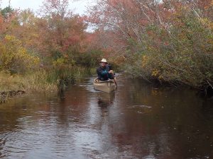
Besides the remote, wilderness feel so often (and so easily) encountered in here, the topography and hydrology of the Pine Barrens combine to create unusual, if not precisely unique, conditions for paddling. What strikes most folks is the small size of the streams here. They’re called rivers, but back home we’d call them creeks. The relatively small geographical area of South Jersey doesn’t allow enough space for the streams to develop much significant size, or for that matter length, before they dump into the Delaware Bay or the Atlantic Ocean. Indeed, most often paddling is of necessity single file. In many places the river is just not wide enough to accommodate two canoes side by side.
The ground in South Jersey is mostly sand, such that rainwater percolates downward very quickly into the underlying Kirkwood-Cohansey aquifer, and comparatively little runs off to feed tributaries to in turn help feed the volume of these rivers, thus further contributing to their restricted size. This immense aquifer is very shallow – in some places only a few feet below the surface – and the Barrens rivers are fed primarily by constant upwellings from below. Because of this, there is a surprisingly strong current that you just wouldn’t expect in such flat terrain with only a barely discernible gradient. Not quite a “pushy” current, but certainly “insistent”.
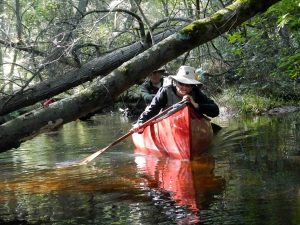
And flat it certainly is. Like streams in flat terrain everywhere, these rivers meander, and that in the extreme. Numerous sharp and usually blind bends, many of 90̊ or better, come up quickly and continuously. Not to mention the occasional overhanging limbs or submerged logs that require maneuvering to avoid. And all of this with a pretty decent current behind you.
There are at least four rivers within the Wharton tract – The Batsto, Wading, Oswego, and Mullica. Let’s describe a couple of them:
Batsto River – upper section – Hampton Furnace to Quaker Bridge – 6 miles (thereabouts)
3 miles into the forest on a sand road brings one to the site of Hampton Furnace, a now long-gone iron making facility. The Batsto here is a very narrow river, only a canoe-length wide, and at the put-in is usually quite shallow with just enough water to float your boat. Like all the rivers here, and small streams everywhere, the narrowness allows plenty of opportunities for the occasional downed tree or overhanging branch which must be negotiated. Because of their close proximity to large population centers, these rivers are heavily used by paddlers in the summer months, and the local outfitters make an effort to cut openings in any downed timber where that is necessary, though the openings thus generated are usually only wide enough to just pass through. Still, there is still a duck-under or two here and there (“limbo logs”) and on rare occasions a lift-over of one sort or another. The water runs tannin-colored as a result of the pine and cedar detritus of the dense surrounding forest.
The area has a very boreal feel about it. The forest grows atop the sands rather than the granite shield of the north, and the terrain is certainly not as rugged as the boreal woods, but the feel is quite similar.
Our meandering course took us by an old now-unused wooden railroad trestle crossing the river. The four solo canoes in our party easily passed through the timber piers, but the two tandem canoes were not able to pass over the eroded ends of some old wooden pilings in the passage. The paddlers bush-whacked a few yards to the other side of the trestle, and the tandem canoes, thus unweighted, were easily lined through to the other side.
A few miles downstream we pulled off to a lunch spot on a high sand bluff overlooking the river. At some bends, the river has cut into the bank to form a fairly large and curving swath of white sand. These features are common along these rivers, and any stretch of river you may paddle here will have several of them along the way. One usually comes upon them unexpectedly – suddenly, as it were -and they are almost startling in their brightness. They make excellent stopping points.
Four miles below Hampton Furnace one comes along the Lower Forge campsite. This is a primitive camping area that is accessible only to paddlers, or to hikers along the Batona Trail. And just 2 miles below that is the take out at Quaker Bridge, a small one-lane bridge carrying – wait for it – Quaker Bridge road over the river. The original bridge was built in the 1770s and this road was one of the main thorofares between Philadelphia and the town now called Tuckerton on Barnegat Bay. It remains a single-lane sand road today.
Oswego River – Oswego Lake to Harrisville Lake – 7 miles
The most commonly paddled part of this short river begins and ends in small lakes, the river running about 7 miles between them. The Oswego features the same narrow, twisting characteristics and tea-colored” water common to Barrens rivers, and a bottom that alternates between areas of sand and areas of pea-size gravel. The first 4 miles or so take you through one of the most striking and affecting places to be found here.
The banks are lined with numerous intermittent and very densely packed groves of mature Atlantic White Cedar. These tall groves are dark and silent, and in their way majestic, commanding your attention. Paddling through here seems to have the same unbidden effect on people, whether they are first timers, or have been here before. One is simply hushed by this forest, not wanting to disturb it with a single spoken word, nor a careless paddle splash. If anything is said, one just naturally does so in a whisper. One of our friends refers to these miles as “the Cathedral”, and it is an apt description. It is a remarkable place.
Beyond here the river opens into a small marsh, known as Martha Pond. Numerous braided channels and small islands to choose among for passage. At the lower end, and at mile post 5, there is a small cove on the left that makes a good lunch spot, and is near the site of an old iron ore firing kiln (Martha Furnace, built in 1793) and the town of some 50 houses that grew up around it, now entirely vanished with little evidence that it was ever here. A couple more miles through the forest brings one to Harrisville Pond and the take out. A highly recommended trip.
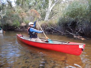
Paddling these rivers certainly puts your skills to the test, and requires your constant attention, and it is a Joy. As some of you know Anita and I have been involved with FreeStyle canoeing for a number of years now, both solo and tandem, but more the latter. Like many folks we were first attracted to it after seeing some Interpretive FreeStyle – paddling routines to music. We were smitten with the demonstration of precise control and seemingly effortless grace, and wanted to try to learn to paddle like that.
It wasn’t ‘til some little time later that we realized that in learning the various FreeStyle maneuvers, we were also learning to paddle more effectively, more accurately – to become better partners with our boat, to work with it better. And learned also what a dramatic difference it made in our “everyday” paddling back home.
Among many other things, FreeStyle stresses the fundamental notion that in tandem paddling the bow and stern are a Team, with each position having its own responsibilities and repertoire of strokes, static placements, and other techniques to utilize. The bow paddler handles the bow, and the stern paddler handles the stern. The Team works together to help guide the boat where you want it to go, and how you want it to get there – what you want the canoe to do.
See more Cross Post articles HERE